
-
1:47

Freezing rain moves in tonight, expecting slick roads tomorrow...
-
1:24

Happy feet hit the floor at 24th Annual Daddy Daughter Dance
-
3:35

New house bills could reorganize local school corporations
-
1:58

New era underway at Knollwood Country Club
-
3:51

Local Police Departments concerned over House Bill 1186
-
2:55

’Save Lakeside Woods’ successfully buys land back from developer,...
-
3:26

SBCSC announces community partnership to improve school literacy
-
2:21

Freezing rain reaches Michiana Wednesday night
-
2:25

Potential ice jamming in New Buffalo
-
2:31

The History Museum’s ’Worker’s Home’ brings 1950s African...
-
1:39

Cloudy and cooling down today with a wintry mix tomorrow
-
0:52

Mishawaka High School holds signing day for student athletes

Steady rain is likely to continue overnight Monday into Tuesday morning with temperatures slowly falling into the 40s.
The soggy weather continues Tuesday with little to no warm-up in temperatures. The official high for Tuesday may come just after midnight in the 50s but the waking hours will be in the mid to upper 40s. Final rainfall estimates through Wednesday morning could be more than three inches since Monday. Our first frost may be in the forecast Thursday morning.
Tonight: Rainy, low 46. 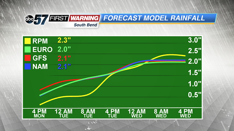 Additional rainfall estimates from Monday afternoon to Wednesday afternoon. We could see another 2
Additional rainfall estimates from Monday afternoon to Wednesday afternoon. We could see another 2
Additional rainfall estimates from Monday afternoon to Wednesday afternoon. We could see another 2
Tuesday: Cloudy and rain, temperatures in the mid to upper 40s.
Wednesday: Mostly cloudy with lake effect rain. High of 48.
Thursday: Chilly start, mostly sunny with highs near 60.