Wet Tuesday then HOT past midweek

-
1:47

Freezing rain moves in tonight, expecting slick roads tomorrow...
-
1:24

Happy feet hit the floor at 24th Annual Daddy Daughter Dance
-
3:35

New house bills could reorganize local school corporations
-
1:58

New era underway at Knollwood Country Club
-
3:51

Local Police Departments concerned over House Bill 1186
-
2:55

’Save Lakeside Woods’ successfully buys land back from developer,...
-
3:26

SBCSC announces community partnership to improve school literacy
-
2:21

Freezing rain reaches Michiana Wednesday night
-
2:25

Potential ice jamming in New Buffalo
-
2:31

The History Museum’s ’Worker’s Home’ brings 1950s African...
-
1:39

Cloudy and cooling down today with a wintry mix tomorrow
-
0:52

Mishawaka High School holds signing day for student athletes

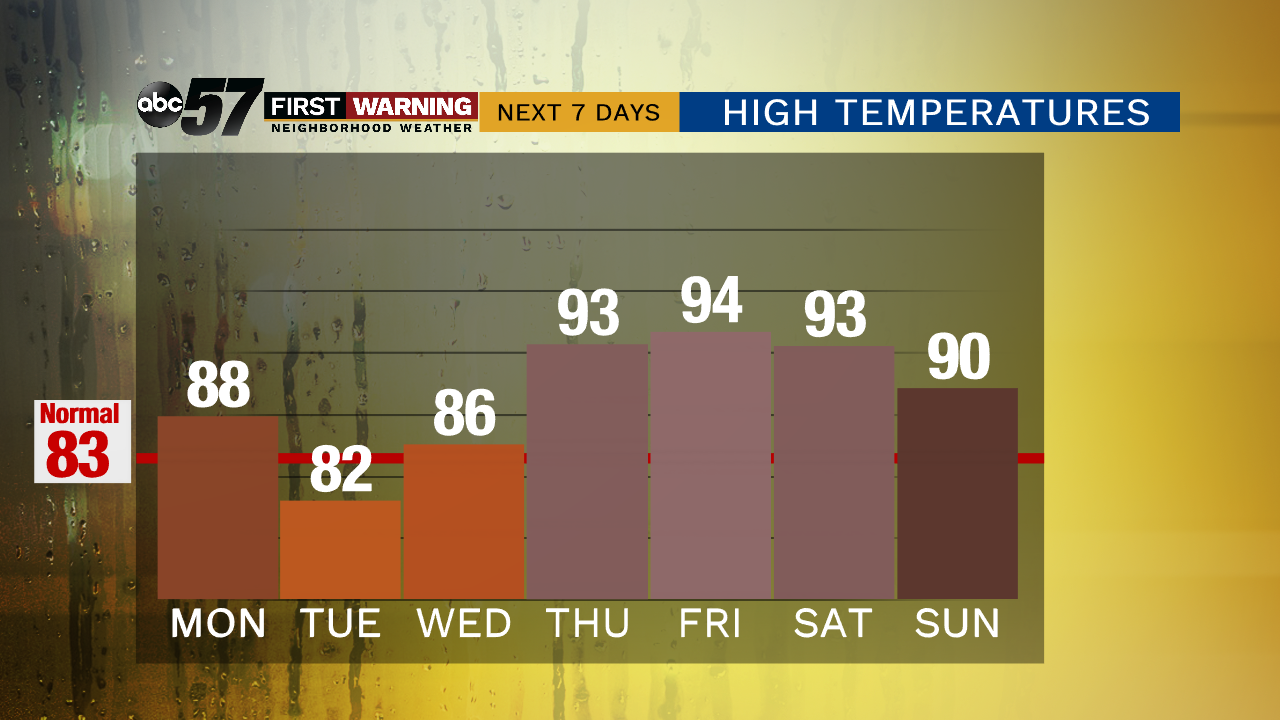
It’s another hot and humid day but today’s heat is nothing compared to what’s to come past midweek. We’ll have plenty of sunshine to cool off by the pool with just an isolated shower possible this afternoon. The widespread showers move in tomorrow from what is left of Barry (the Hurricane that hit the Gulf Coast). This keeps us “cooler” before temperatures climb again on Wednesday.
Temperatures soar into the low to middle 90s for Thursday all the way through Sunday. It is going to feel even hotter as heat indices will be over 100 degrees. This kind of heat can be dangerous, so make sure you’re staying hydrated and takes breaks from the heat. Relief from the heat comes Sunday evening as a cold front swings through, bringing showers and storms.
Today: Plenty of sun and humid, an isolated storm, high of 88.
Tonight: Mostly cloudy, chance of rain late, low of 71.
Tuesday: Mostly cloudy with a few showers & storms, high of 82.
Wednesday: Partly to mostly cloudy, slight chance of a shower, high of 86.