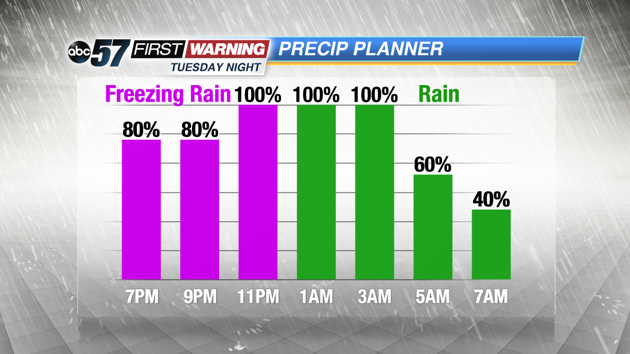
Tuesday's temperature swing brings concern for freezing rain

-
2:44

Warmer, breezier, and cloudier than yesterday
-
0:46

Crowds gather for Fins and Feathers Fest at La Porte City Fairgrounds
-
0:46

Paramount School of Excellence hosts teacher fair
-
2:30

Voting advocacy, peaceful demonstrations and donations: South...
-
2:04

Warming to start the week, Showers and storms by Tuesday
-
2:10

Cool, but calm, today
-
1:23

City of South Bend presents an ’Age-Friendly Plan’ to better...
-
0:54

South Bend Venues Parks and Arts hosts ’Adult Recess’
-
2:27

Why Aneyas Williams turned down the transfer portal and stayed...
-
2:21

Bourbon community rallies around Triton boys’ basketball team...
-
5:02

Dave Matthews shares details about LLC bankruptcy filings
-
1:00

Warming up this weekend before more storms next week

A swing in temperatures Tuesday into Wednesday will bring a wintry mix of weather, the top concern being freezing rain Tuesday evening. Temperatures rise from the single digits into the 20s Tuesday afternoon, as a chance of snow builds. Temperatures rise toward 32 degrees Tuesday evening, window for freezing rain looks to be between 6:00 p.m. and midnight. All rain early Wednesday before temperatures crash again. A very cold and active winter pattern continues in the extended forecast.
Tonight: Partly to mostly cloudy, low of 4.
Tuesday: Mostly cloudy, snow →sleet → freezing rain → rain builds into the evening, breezy with a late high of 34.
Wednesday: Morning mix changing to snow, temperatures falling from an early high of 34 degrees.
Thursday: Lake effect snow showers, high of 24.