Fall system brings rain then snow and bitter cold

-
1:48

Summer-like stretch ended by thunderstorms late Friday night
-
2:15

South Bend Police honors department members in 2024 awards ceremony
-
0:48

Women’s Impact Panel at Saint Mary’s College celebrates local...
-
3:07

Residents voice concerns over new sewer district
-
2:43

Fire crews spend hours working to put out flames at The Mill...
-
2:03

Head Coach of Washington High School Girl’s Basketball Team...
-
3:03

South Bend Walmart addresses parking lot potholes
-
0:39

Motorcyclist and passenger dead Wednesday afternoon after collision...
-
1:54

Very warm end to the week with storms and wind ahead
-
3:15

One currently hospitalized after reported explosion at Lock...
-
1:10

St. Joseph County Sheriff files motion to dismiss lawsuit brought...
-
0:59

Fire attacks The Mill apartment complex Wednesday morning

Monday, December 9th, 2019
Scattered rain showers last on and off through today. The cold air begin to move in tonight, briefly changing the rain to snow as the system moves out. Little to no accumulation is expected from the system. The cold air will drop our temperatures in the low 50s today to the middle 20s by tomorrow evening. From the falling temperatures, icy spots will be possible on the roads Tuesday morning.
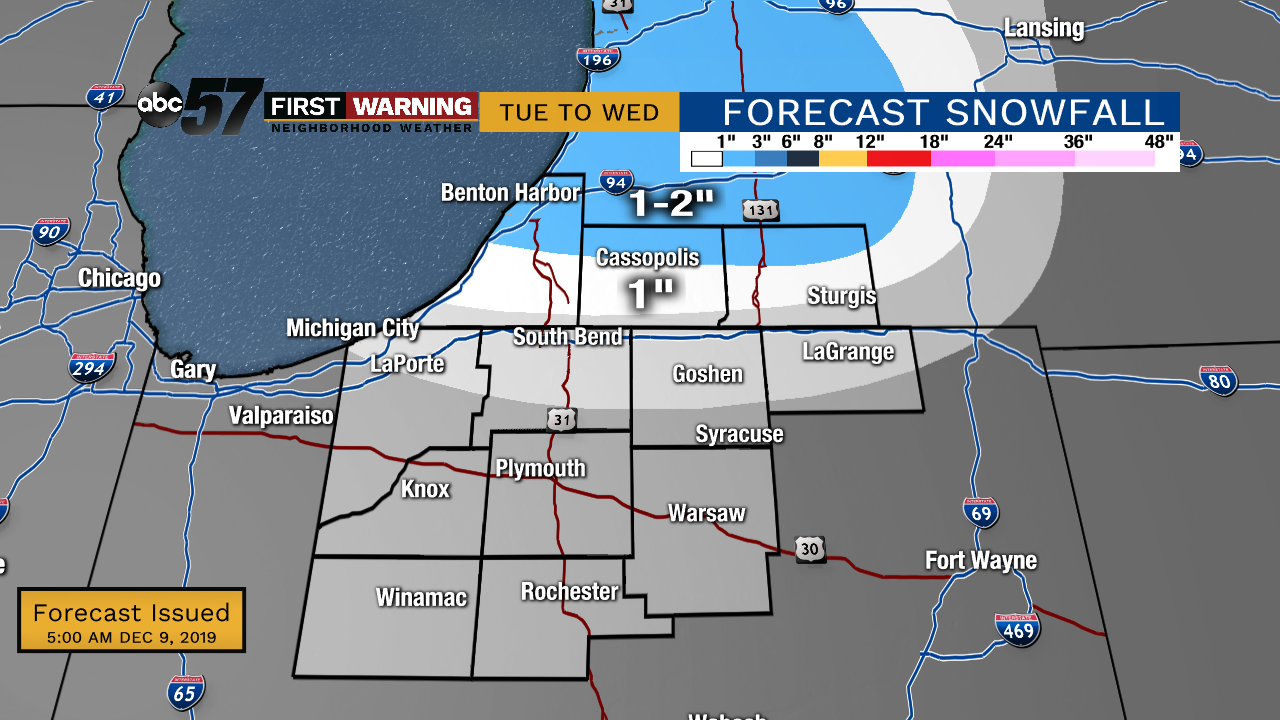
As winds shift from the NW to W, some lake effect snow will be possible Tuesday into Wednesday. This will mainly be fore our Michigan counties where they could see 1-3" of snow while most in our Indiana counties will see an 1" or less. Otherwise, those of you in our Indiana counties will notice clouds starting to break past midday Tuesday. The bitter cold will keep us in the mid 20s Wednesday with breezy winds making it feel even colder. Warming back up into the next weekend.
Today: Rain showers, especially through midday. Breezy. High of 51.
Tonight: Rain briefly turns to snow. Lake effect snow develops. Low of 32
Tuesday: Mostly cloudy, lake effect snow. Breezy. Temperatures falling from 32 degrees.
Wednesday: Partly to mostly cloudy. Chance of a flurry. High of 24.