
-
3:49

Asking for Accountability: Michiana Elected Officials on on-going...
-
3:37

South Bend Cubs explain weekend washout
-
4:02

Early voting is underway as Indiana prepare for its May 5 primary...
-
3:27

Tax-related scams to watch out for
-
0:09

Crews repair weekend washout under Coloma train track
-
0:58

Chilly and sunny Tuesday ahead
-
0:41

Elkhart police investigating Monday night shooting
-
3:47

Elkhart Police Department accepting applications to Citizens...
-
0:52

A slight warm-up but chilly weather still dominates
-
1:09

Bitterly cold out the door
-
3:03

Looking to younger generations to keep Dyngus Day thriving
-
3:06

Even as rivers recede, Marshall County still dealing with flooding

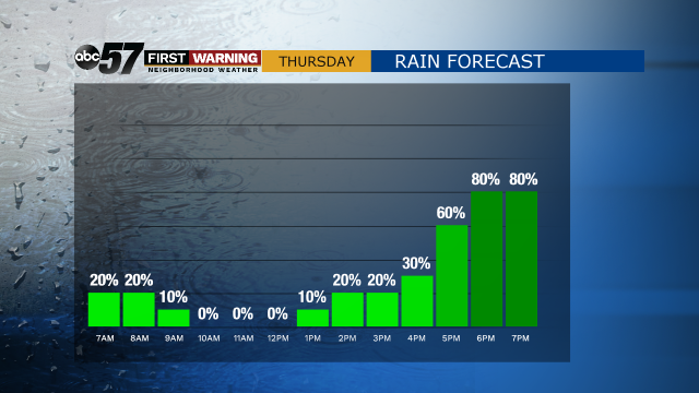
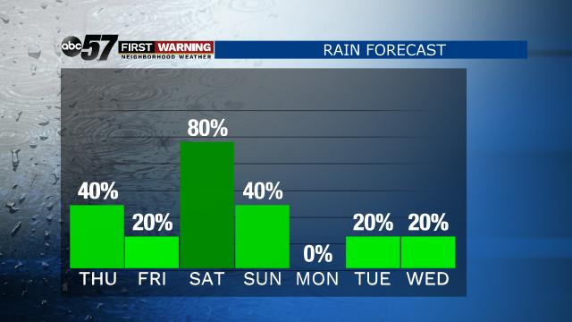
A rainy pattern sets-up to end the week. A few spotty showers are possible Thursday morning, the day is cloudy and widespread rain is likely by the evening. Friday is a lull between rounds. Heavy rain is likely from late Friday night through most of Saturday. In total upwards of two inches of rain are possible by Sunday. Thunderstorms are possible but severe weather is not expected, flooding is also unlikely. The best time to be outside is before 3 PM Thursday and Friday afternoon.
Tonight: Increasing clouds, chance of rain late. Low 46.
Thursday: Spotty morning shower, then evening rain. High 58.
Friday: Cloudy. High 56.
Saturday: Rain/Thunder Possible. High of 62.
Sign up for the ABC 57 Newsletter