Threat of flooding not immediate, but could be building for Michiana

-
4:24

Michiana Crime Stoppers shredding event
-
1:16

’IvyCares’ program setting students up for success in and...
-
1:45

Windy and wet this weekend, but unseasonable warmth as well
-
3:13

Local players react to $3 million investment in Byer Softball...
-
0:32

Layoffs at Whirlpool could affect workers in Benton Harbor
-
1:03

Annual District Sisterhood Conference at Ivy Tech empowers students
-
1:49

Back home in downtown South Bend, YMCA to open new location
-
2:16

This week’s ABC57 Cub Reporter is Nicholas Zentz
-
3:05

Amazon Web Services invests $11 billion to build data center...
-
4:05

Riley High School student center stage at the NFL Draft
-
1:35

Rain, wind, and milder temperatures forecast this weekend
-
2:49

Joe Alt expected to be drafted in the first round of NFL Draft

After a dry day across Michiana on Monday, steady rain has returned to the area Tuesday. Rain chances will persist throughout most of Tuesday night and for portions of Wednesday.
Steady rain and breezy tonight. https://t.co/81y0RPEq1H | #inwx #miwx pic.twitter.com/vcmieIErE5
— Tom Coomes (@TomCoomes) March 22, 2022
Rainfall amounts could top an inch in many locations by the end of Wednesday, with a few heavy downpours possible tomorrow.
Rainfall Estimates ☔️
— Tom Coomes (@TomCoomes) March 22, 2022
Tuesday has the more constant rainfall +0.5” / 24 hrs
Wednesday will have scattered t-showers w/ downpours +0.5” / 6 hrs. https://t.co/81y0RPEq1H | #inwx #miwx pic.twitter.com/uDor5RNHfJ
While flooding is not a major concern in the short term for Michiana, we will have to keep an eye on river levels if the rain keeps up. Right now, a few area rivers and streams are near flood stage, like the St. Joseph River in Niles.
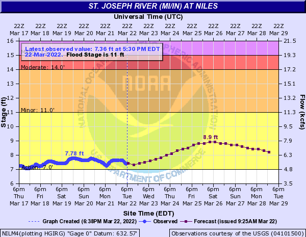
Currently, the forecast crest of approximately 9 feet is still below minor flood stage. However, with more wet weather possible this weekend and at times next week, a gradual flood threat could be building across the area into April.