 Weather alerts as of noon on Tuesday.
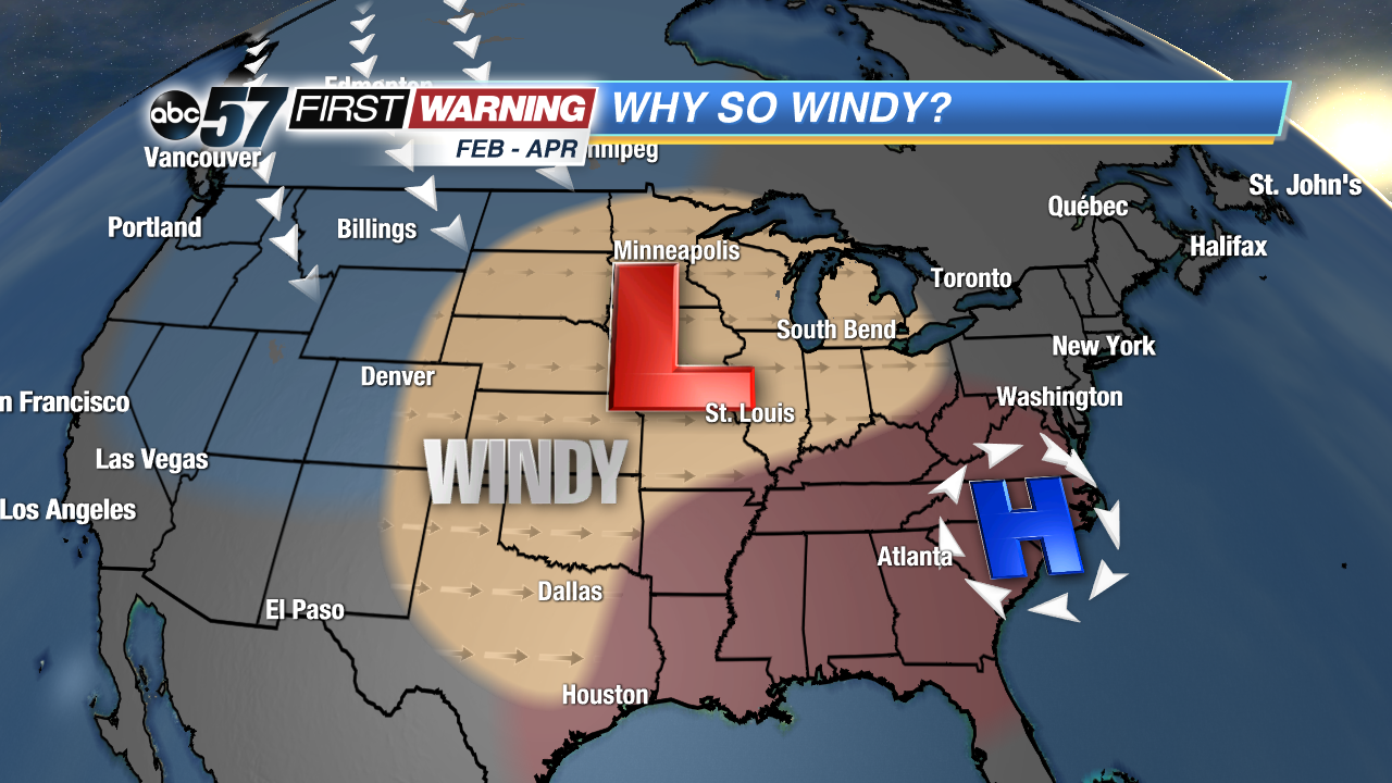
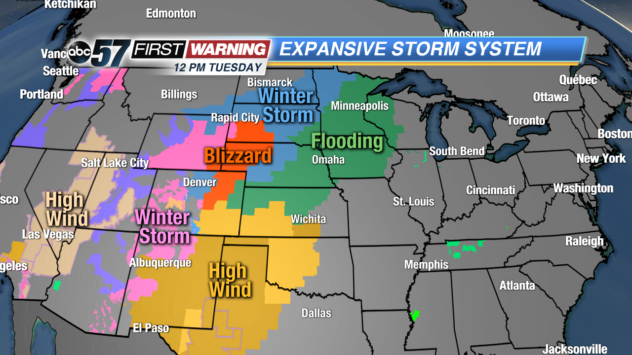
The forecast for the Tuesday night thru Friday morning period is largely unchanged for Michiana. We are still expecting a few rounds of rain, a chance of thunderstorms, strong to very strong wind gusts, and unseasonably warm temperatures. The most notable difference is the addition of a legitimate severe weather threat by Thursday. We'll get to that in a moment. First, let's break down the eventual powerhouse system as it stands Tuesday afternoon. As of 12 p.m., millions are under some sort of significant weather alert. These range from Blizzard and Winter Storm Warnings to Flood Watches and High Wind Warnings.
 Typical set-up for large springtime systems.
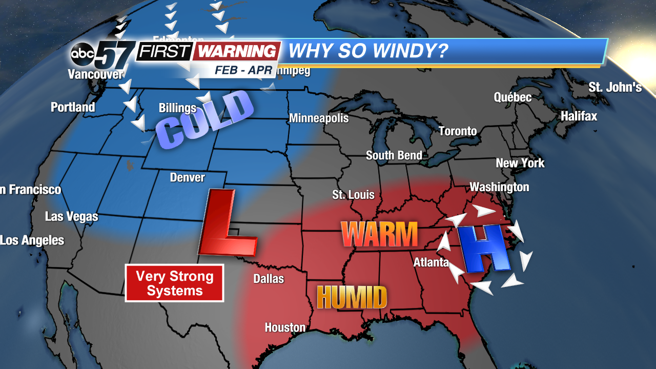
If you look at weather maps, you won't see much until Tuesday night. That's when the storm is set to develop. Throughout the day Wednesday, the low pressure will rapidly intensify and undergo "bombogenesis." That's a fancy meteorological word that essentially means the low will strengthen extremely fast over a short duration of time. This is why it will bring multiple types of impactful weather to the central portion of the country. This is the time of year for these types of systems. Are they all
this strong? Absolutely not. But the period from February thru April and even early May is the "hot zone" for these large, potent and expansive systems in the United States.
The reasoning is actually quite simple. During the months of February, March and April, you can get a "battle" between warm, humid air trying to take over and cold, dry air trying to hold tough. When two opposing air masses collide, you can get these strong areas of low pressure to develop. In many cases there is also a good degree of energy in the atmosphere to support the low. The result? Rapidly strengthening low pressure systems that bring with them blizzard conditions, severe weather and widespread strong wind gusts.
That is
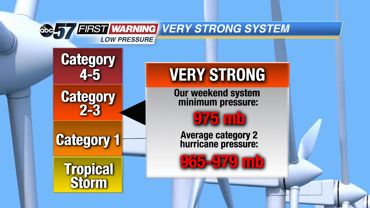
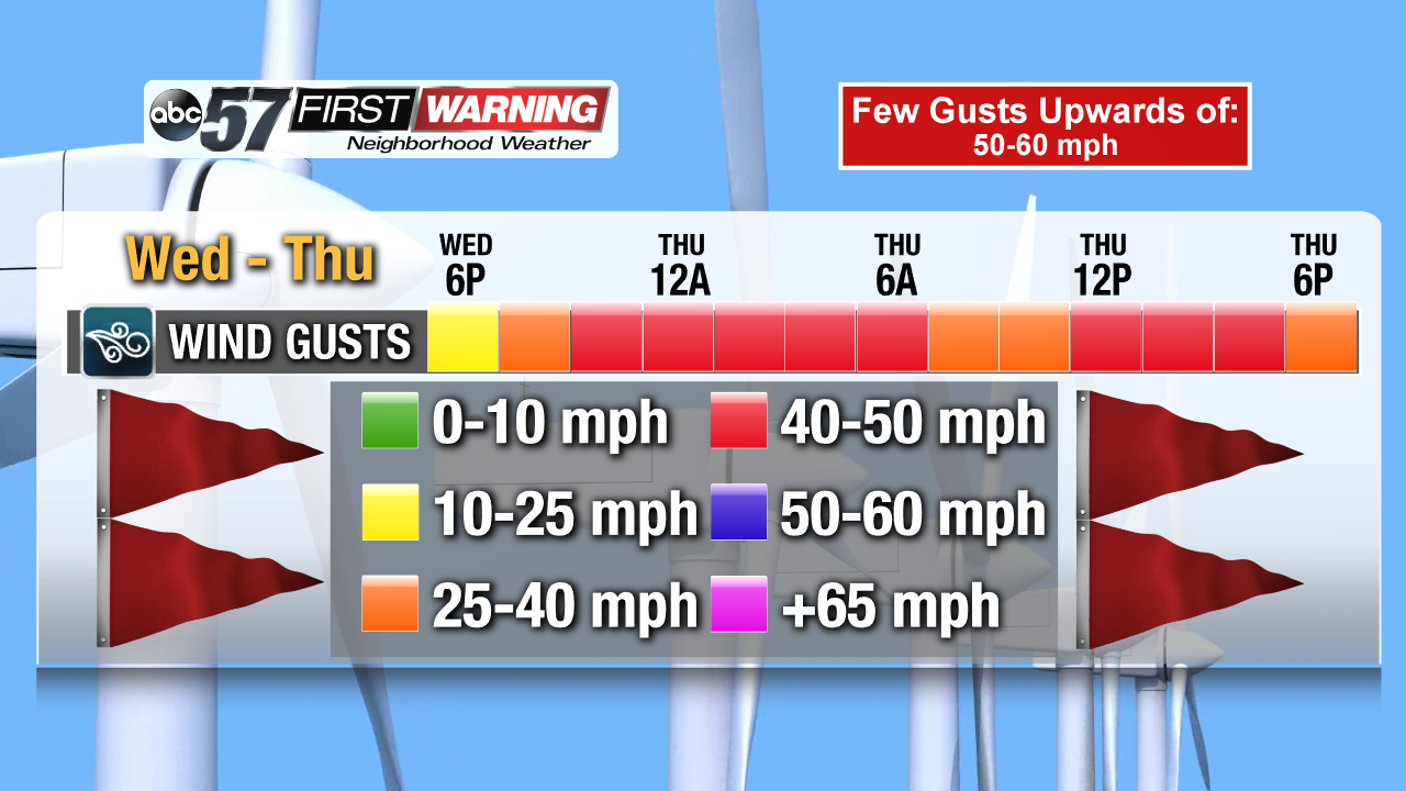
exactly what's setting up with this week's system. But, as mentioned above, this particular system will be stronger than most. By Wednesday morning, the central pressure of the low will drop to roughly 975 millibars over Kansas. Why is that significant? Well, that's the same pressure as a category two hurricane! That's why we are expecting the strong to very strong winds across a good chunk of the country, including right here in Michiana. The latest forecast model data suggest that wind gusts are still expected to exceed 40-50 mph Wednesday night and Thursday.
The potential is certainly there for some gusts of 50-60 mph as well. Keep in mind that these gusts are
not associated with showers or thunderstorms. Any showers or storms that push through Wednesday night or Thursday would only increase the likelihood of gusts over 50 mph.
 Severe thunderstorm outlook for Thursday.
Storm Prediction Center
Severe thunderstorm outlook for Thursday.
Storm Prediction Center
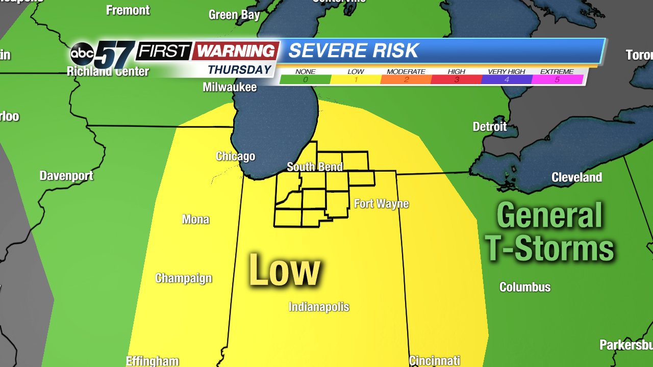
Thus, there is the potential for power outages and even scattered instances of damage across the entire area. Speaking of thunderstorms, all of Michiana is now under a "Marginal" or "Low" risk for severe weather on Thursday. In fact, the entire state of Indiana and adjacent portions of Illinois, Ohio, Kentucky, and Michigan fall under that same severe risk. That risk is associated with the significant system just like our strong winds. The timing for severe weather would likely be 10 a.m. to 6 p.m. Thursday. The main threats are damaging wind gusts, isolated hail and a few tornadoes.
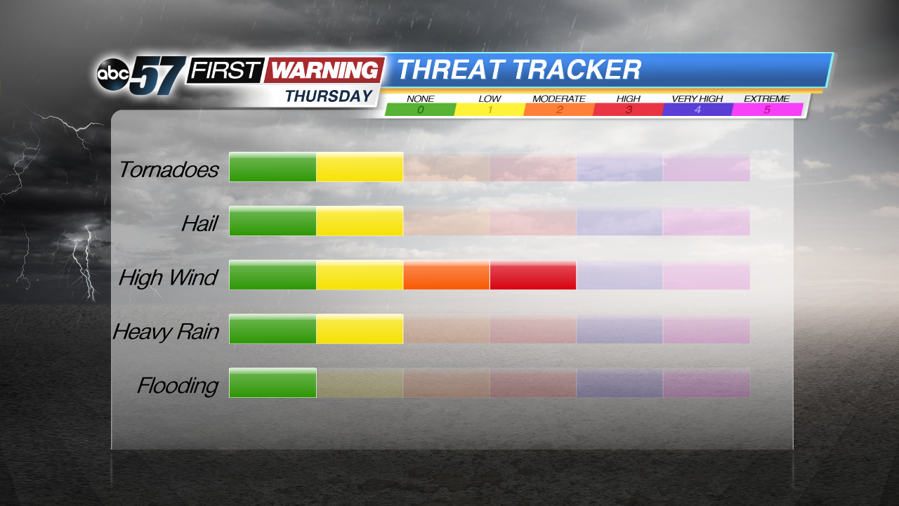
The most substantial risk will be damaging winds. As mentioned above, any showers or storms that push through will combine with the already strong winds in place and create an even higher wind threat. It will be important to be weather aware on Thursday, and have a way to receive pertinent weather information like watches, warnings and advisories. Otherwise, prepare for a windy and mild stretch beginning Wednesday!