
-
2:34

From Niles to South Bend: Jays 2 Keeps the Spirit Alive for basketball...
-
0:46

44th annual Tri Kappa Antique Show boosts charities and scholarships
-
1:48

Scattered showers this evening, Much cooler overnight
-
1:50

Showers and storms this afternoon
-
0:20

One person injured in shooting
-
0:36

Eddies Circuit Robotics holds competition Saturday
-
0:32

21st annual Nappanee Model Train Show
-
0:38

Local boys basketball team headed to IHSAA state finals
-
3:49

Midwest Meowfest brings kitten advocacy to attendees, new homes...
-
1:52

Mild tonight, showers tomorrow
-
1:43

Pleasant to start the weekend
-
3:06

Pulaski County weighs stricter solar rules amid resident concerns

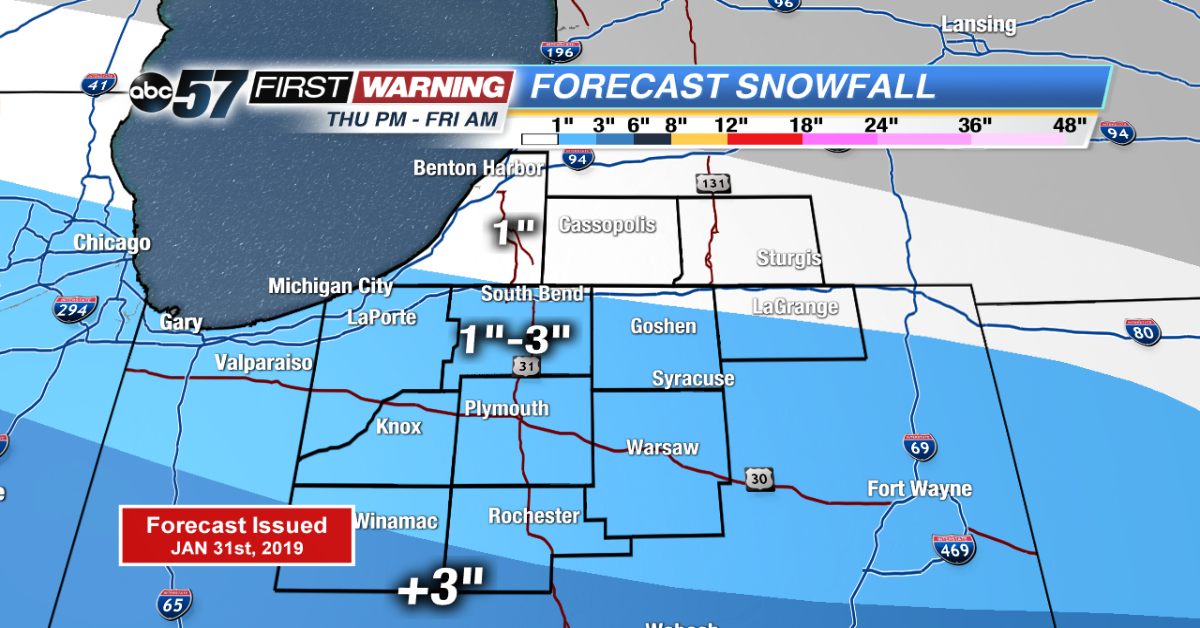
The deep freeze is over as temperatures warm above zero overnight. Light snow will bring a range of one to three inches of snow through Friday morning. Snow ends before the morning drive.
Temperatures are on the rise, a weekend thaw will bring highs in the 50s by Monday. Once temperatures rise above freezing Saturday, they are likely to stay there through Monday evening. The melt will be steady but flooding concerns are nowhere near last February when six to eight inches of rain and meltwater were released. This round looks to be maybe two inches max.
Tonight: Overnight snow, temperatures warming from -2.
Friday: Mostly to partly cloudy, high of 22.
Saturday: Partly cloudy, fog possible, high of 42.
Sunday: Mostly cloudy, chance of showers, high of 48.