Rain moves out this morning; wind becomes main impact

-
1:45

Windy and wet this weekend, but unseasonable warmth as well
-
3:13

Local players react to $3 million investment in Byer Softball...
-
0:32

Layoffs at Whirlpool could affect workers in Benton Harbor
-
1:03

Annual District Sisterhood Conference at Ivy Tech empowers students
-
1:49

Back home in downtown South Bend, YMCA to open new location
-
2:16

This week’s ABC57 Cub Reporter is Nicholas Zentz
-
3:05

Amazon Web Services invests $11 billion to build data center...
-
4:05

Riley High School student center stage at the NFL Draft
-
1:35

Rain, wind, and milder temperatures forecast this weekend
-
2:49

Joe Alt expected to be drafted in the first round of NFL Draft
-
2:11

Students gearing up for local careers in Manufacturing
-
2:13

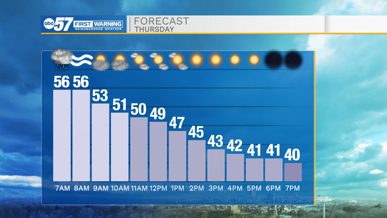
Sunny today, but expect a wetter and warmer weekend

Light rain showers/mist wrap up early this morning. You may not need the umbrella out the door, but be prepared for plenty of puddles on the ground.
We start mild: temperatures this morning are in the mid 40s, and we continue to warm into the low 60s by afternoon.
Wind picks up as the day goes on, and becomes most intense overnight/early Thursday morning. Some gusts early Thursday could be 45+ mph.
Gusts this speed are enough for some power line or tree damage. You'll also want to secure any holiday decorations.
Another round of rain will take us into Thursday morning, but we are dry by afternoon.
Enjoy temperatures in the upper 50s tomorrow morning, but be prepared for falling temperatures by Thursday afternoon.
Friday looks quiet and cooler, with a round of rain/snow showers possible into early Saturday morning.
Temperatures in the mid 30s to low 40s continue through the weekend and next week, with no promising snow in the forecast.
Today: AM showers. Windy and cloudy. High 62.
Tonight: Windy. Rain showers late. Low 56.
Thursday: Windy. Falling temperatures from 58.
Friday: Mostly cloudy. High 43.