Hot and dry for now but storms coming on Wednesday

-
2:10

Sunny Monday ahead, but showers and thunderstorms later this...
-
2:10

Plymouth High School hosts ’Steps for Stegs’
-
2:05

Drier but cooler to wrap up the weekend
-
6:23

ABC57’s Arts and Acts: Local dance stars shine at A&A Ballet...
-
2:49

St. Adalbert Church celebrates Cinco De Mayo, announces fundraising...
-
0:40

Congressman Rudy Yakym awards local high school artists
-
2:06

Thundershowers tonight, a cooldown tomorrow following cold front
-
0:52

Bethel University celebrates 77th commencement
-
1:36

Beautiful start to the weekend despite morning fog
-
1:03

’Pedals and Petals’ in downtown South Bend
-
3:18

Owners urged to vaccinate dogs after puppy left for dead outside...
-
1:54

Threat of drought, even with rainy spring in Michiana

 Air Quality Alert still in effect for all the counties in green for today and Monday.
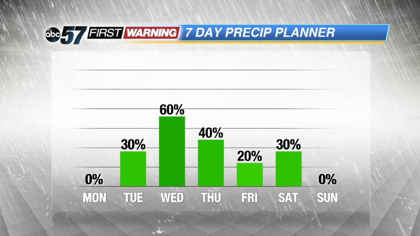
We’ll have a couple more 90 degree days ahead of us to start the work week. Monday and most of Tuesday will be dry as well, but showers and storms will slide into the area as early as late Tuesday afternoon. Rain chances will stick around through the late week and into the weekend. By next Saturday and Sunday, highs will fall into the lower 80s and finally into the upper 70s by next Monday.
There is an Air Quality Alert in effect for everyone in LaPorte, St. Joseph, Elkhart, Berrien and Cass counties today and Monday. Ozone levels are expected to be unhealthy for those in the sensitive group.
 Dry for now but good rain chances come in for Wednesday
Tonight: Clear, low of 70.
Monday: Sunny, high of 92.
Tuesday: Partly sunny, chance for some showers in the evening. Highs close to 90.
Wednesday: Mostly cloudy with scattered showers and T-storms. Highs in the upper 80s.