Severe weather in the southeastern US today

-
1:52

While the rain is over, the cooling temperatures are not
-
2:28

Public forum hosted by John Glenn High School students
-
3:34

Kickoff preview with ABC57’s Allison Hayes
-
0:57

Completion of Martin Luther King Jr. Dream Center one step closer
-
0:36

Niles High School students network with local professionals
-
3:59

Political group asks Indiana Democrats to vote in Republican...
-
3:01

New Buffalo Area Schools to build workforce housing
-
2:37

City seeks feedback for final Potawatomi Park plan
-
7:27

Center for the Homeless hosting Dancing With Our Stars
-
2:10

More wet weather arriving later tonight, but sunnier skies after
-
3:16

Public input on the proposal to restart the Palisades Nuclear...
-
1:35

Dari Fair opened Wednesday for 2024 season, temperatures cool...

Portions of the southeastern US, especially in the Mississippi Valley, are under a 4/5 risk for severe weather today with the main impacts from this storm system happening this afternoon into tonight. There is a high risk for strong thunderstorms, damaging winds, and large hail. Long-track and significant tornadoes (EF2+) are also possible.
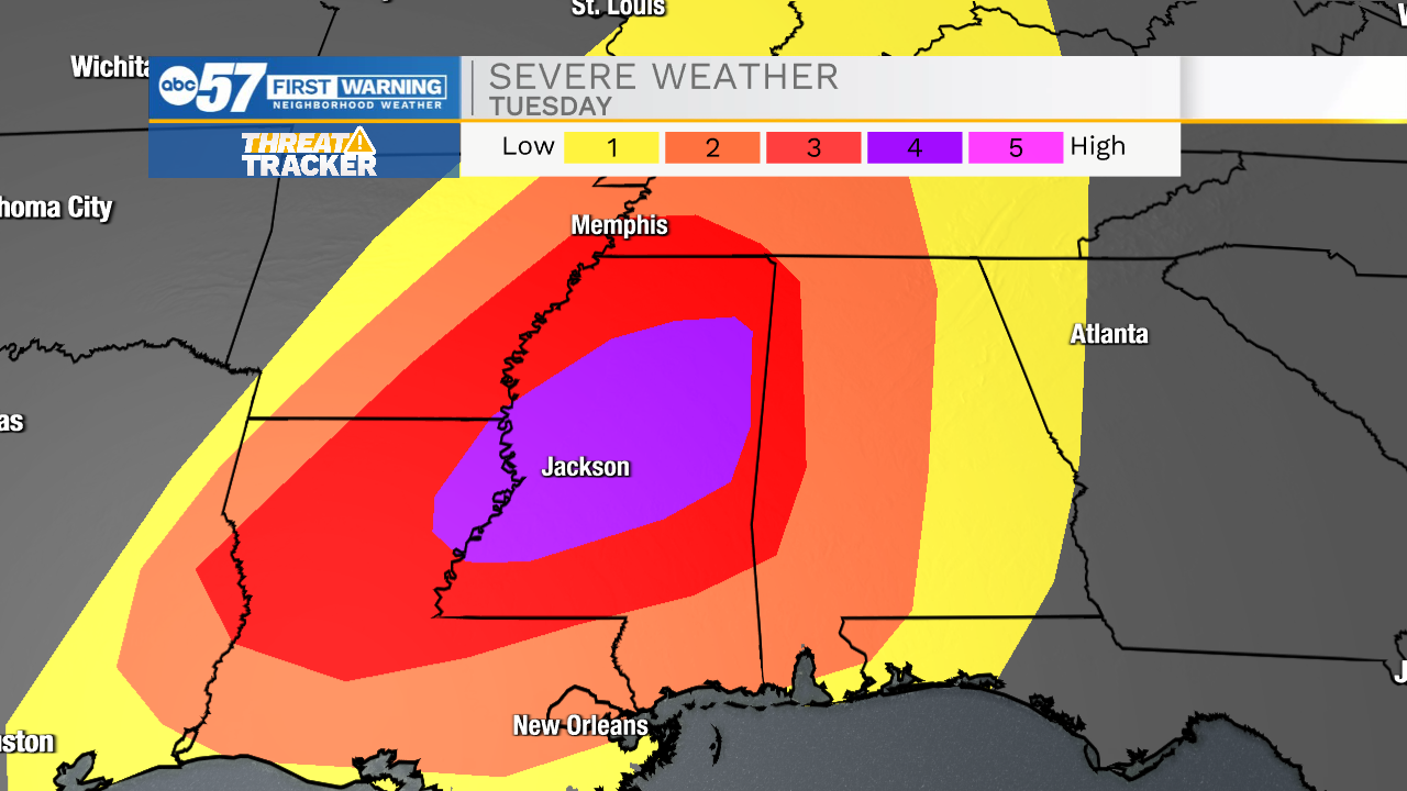
Winds moving onshore from the Gulf of Mexico will bring warm, moist air to the southeastern US. Temperatures will be warm in the mid 60’s and nearing 70 with dewpoints not far behind which will provide plenty of moisture to fuel storm development. Instability in the atmosphere will make severe weather more favorable and could create dangerous situations for many in the southeast.
Anyone with friends or family in this region should reach out to their loved ones to ensure that they are staying weather aware today, have multiple ways to receive weather information, and have a shelter plan in place.