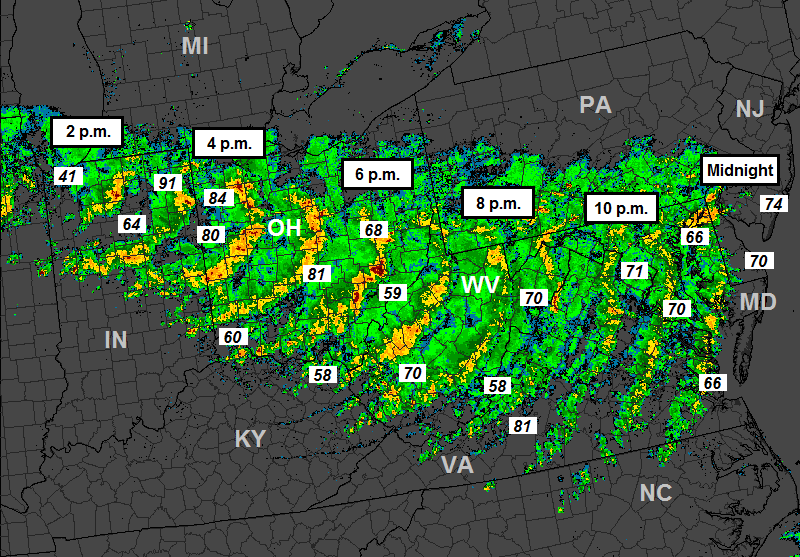
The radar loop below shows the infamous derecho -- a widespread and long-lived windstorm -- from June 29th of 2012
It formed over Northern Illinois, grew and charged east-southeast toward the East Coast. It delivered strong to damaging wind gusts to Michiana and all of Northern Indiana. A wind gust of 91 mph was recorded in Fort Wayne with multiple 80+ mph gusts occurring in Ohio.
June 29th, 2012 derecho.SPC
The derecho began just after lunchtime and didn't dissipate until after midnight, producing a 12-hour window of intense wind and rain. It is certainly not the only such storm to impact this part of the country. It was not the strongest, either. For example, on May 31st, 1998, a high-impact derecho slammed Lower Michigan with wind gusts upwards of 130 mph! Regarding a derecho's damage capability, NOAA's Storm Prediction Center provides some insight in their write-up. In short, these systems can knock out power to millions and millions of people for days, destroy homes, businesses and other structures, and lead to numerous injuries and fatalities.
These derechos are not something we see all that often in the United States, but when they do occur, they are often destructive and certainly memorable.
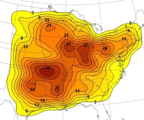
Number of times areas were hit by derechos from 1980 to 2001.SPC/Coniglio and Stensrud 2004
Believe it or not, we here in Michiana are in a hot spot for derechos. Jeffrey Logsdon of the National Weather Service in North Webster, Indiana, had this to say about this part of the country:
"Northern Indiana and Northwest Ohio finds itself in a geographically favorable location to receive these derecho events. Known as the Corn Belt Region, the favored location for this type of event extends from the Upper Mississippi Valley all the way across the Ohio Valley,"
Looking at the map above, you can clearly see that Michiana is located in one of two "bullseyes" across the eastern half of the country. The other hot spot includes parts of Oklahoma, Arkansas and Missouri.
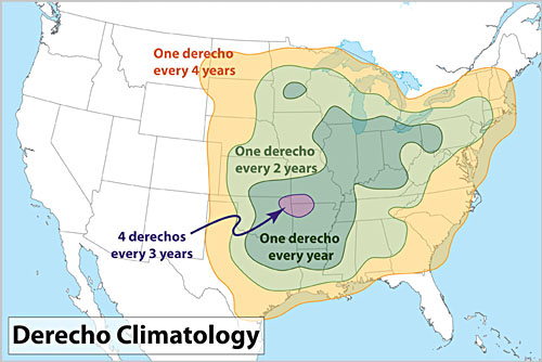
Derecho climatology.Dennis Cain/SPC
When you break it down, Michiana falls in the "one derecho every year" category. On average, we see one of these significant, widespread and long-lived windstorms affect us every year. Do we actually see one every single year? No. Sometimes we go a few years without one. Sometimes we see two or three in a year.
Logsdon put it this way:
"On average, one per year is recorded across this region [Northern Indiana and Northwest Ohio]. However, our last event was back on July 1st of 2014, so you might say that we are a bit overdue for this type of system."
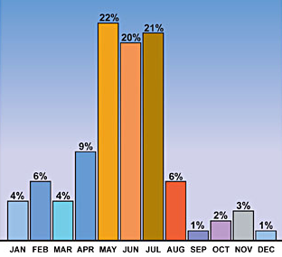
But when do these derechos occur? They have happened in all 12 months of the year, but there is a clear spike from May 1st thru July 31st. Nearly 75% of derechos occur during that 3-month stretch. For Michiana, though, our best opportunity to see a derecho comes in June, July and into early August. That is when the right ingredients of heat, abundant moisture, stationary fronts, significant increases in wind speed with height, and cold temperatures up in the atmosphere. Forecasting these events is still not an exact science, but with technological advancements in the world of meteorology, the ability to more accurately forecast when and where they will occur is getting better and better.


 June 29th, 2012 derecho.
 Number of times areas were hit by derechos from 1980 to 2001.
 Derecho climatology.
 Time of year when derechos occur.