Chilly weather ends, warmer and wetter and of the week

-
2:32

County Council asks questions on 900-acre Granger rezoning and...
-
0:56

Notre Dame women’s basketball team holds end-of-season awards...
-
0:45

Idea Week kicks off with networking at launch party
-
2:59

SBPD officer takes in six puppies while SBARC remains on Parvo...
-
1:45

How rain is hampering planting progress
-
2:43

From classrooms to rental units in Chikaming Township
-
1:47

Cooler and drier midweek, milder and wetter weekend
-
2:36

Aspiring chefs are cultivating their dreams at Ivy Tech
-
1:40

Rainy and breezy Tuesday
-
0:58

Hockey team hosts ’Rally for Rudy’ car wash
-
1:06

South Bend School Board of Trustees reviewing the code of conduct
-
2:33

Newly annexed land in Mishawaka could see a Gurley Leep auto...

Frost: One last chilly night. Lows could dip again towards the freezing mark, frost will be more patchy tonight but if you have flowering plants is an open exposed area bring them inside or cover them up.
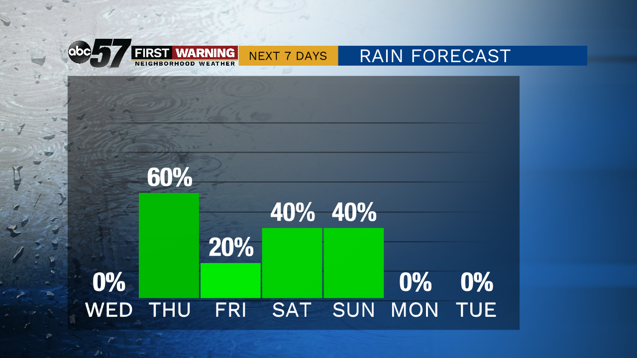
Fair and mild weather continues Wednesday before a rainy end to the week. The chance of rain is Thursday through Sunday, with Thursday night and Saturday night the most widespread rain. Thunderstorms are possible but severe weather remains unlikely. These will be rumbles of thunder embedded inside widespread rain. Friday afternoon and Sunday afternoon are the best chances for a break in the rain. Temperatures continue to rise next week, fair with highs nearing 80.
Tonight: Mostly clear. Low of 36.
Wednesday: Mostly to partly sunny. High of 65.
Thursday: Scattered thundershowers. High of 72.
Friday: A chance of rain. Cloudy. High of 70