Hot and dry for now but storms coming on Wednesday

-
2:32

County Council asks questions on 900-acre Granger rezoning and...
-
0:56

Notre Dame women’s basketball team holds end-of-season awards...
-
0:45

Idea Week kicks off with networking at launch party
-
2:59

SBPD officer takes in six puppies while SBARC remains on Parvo...
-
1:45

How rain is hampering planting progress
-
2:43

From classrooms to rental units in Chikaming Township
-
1:47

Cooler and drier midweek, milder and wetter weekend
-
2:36

Aspiring chefs are cultivating their dreams at Ivy Tech
-
1:40

Rainy and breezy Tuesday
-
0:58

Hockey team hosts ’Rally for Rudy’ car wash
-
1:06

South Bend School Board of Trustees reviewing the code of conduct
-
2:33

Newly annexed land in Mishawaka could see a Gurley Leep auto...

 Air Quality Alert still in effect for all the counties in green for today and Monday.
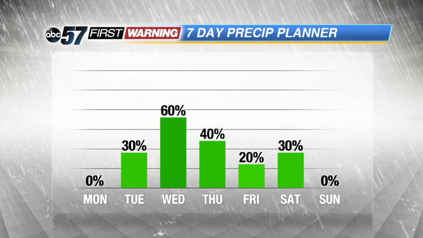
We’ll have a couple more 90 degree days ahead of us to start the work week. Monday and most of Tuesday will be dry as well, but showers and storms will slide into the area as early as late Tuesday afternoon. Rain chances will stick around through the late week and into the weekend. By next Saturday and Sunday, highs will fall into the lower 80s and finally into the upper 70s by next Monday.
There is an Air Quality Alert in effect for everyone in LaPorte, St. Joseph, Elkhart, Berrien and Cass counties today and Monday. Ozone levels are expected to be unhealthy for those in the sensitive group.
 Dry for now but good rain chances come in for Wednesday
Tonight: Clear, low of 70.
Monday: Sunny, high of 92.
Tuesday: Partly sunny, chance for some showers in the evening. Highs close to 90.
Wednesday: Mostly cloudy with scattered showers and T-storms. Highs in the upper 80s.